Understand Safari Tier Ratings & Experiences In Zambia | Why Visit Zambia For Your Safari Vacation Or Holidays In Africa
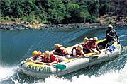
ZAMBEZI RIVER IN ZAMBIA
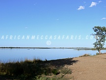
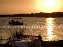
The Zambezi is Africa’s fourth largest river system, after the Nile, Zaire and Niger Rivers. It runs through six countries on it’s journey from central Africa to the Indian Ocean. Its unique value is that it is less developed than others in terms of human settlement and many areas along it’s banks enjoy protected status. It’s power has carved the spectacular Victoria Falls and the zigzagging Batoka Gorge. The Zambezi has been harnessed at various points along the way including the massive Kariba Dam between Zambia and Zimbabwe and Cabora Bassa Dam in Mozambique. Plans for another dam at the Batoka gorge have fortunately been shelved. The River’s beauty has attracted tourists from all over the world providing opportunities for a myriad of water sports and game viewing. Running for a length of 2700kms, it begins it’s journey as an insignificant little spring in the corner of north-west Zambia in the Mwinilunga District. It bubbles up between the roots of a tree, very close to the border where Zambia, Angola and Zaire meet.It enters Angola for about 230kms, where it accumulates the bulk of its headwater drainage, and re-enters Zambia again at Cholwezi rapids flowing due south but substantially enlarged by the entry of various tributaries. It passes through the flat sandy country of the Western Province, then traverses the broad, annually flooding Barotse Plains, where much of the water is lost to evaporation, then over more rocky country where it’s tranquil course is interrupted by the Ngonye falls and rapids.
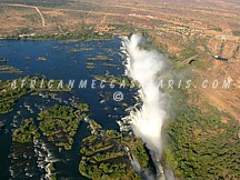
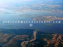
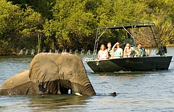
This upper part of the river is thinly populated by pastoralists, farmers and fishermen and although wildlife is sparse it is remarkably free of pollution. This is also the scene of the remarkable Ku-omboka Ceremony where thousands of inhabitants move annually to higher ground as the Zambezi floods into the low lying plains. As it turns to an easterly direction it forms the border between Zambia and Namibia and eventually joins up with the Chobe River in the Caprivi Swamps, briefly forming a border with Botswana. For the next 500 kilometers it serves as the border between Zambia and Zimbabwe thundering over the Victoria Falls and through the narrow, steadily deepening Batoka Gorge which flattens out at the broad Gwembe Valley. From here it flows into the Kariba dam for 281 kilometers – it’s width at one point being 40kms. From the dam wall the river travels due north, heading east again at Chirundu. Here it is flanked by the Lower Zambezi National Park on the Zambian side and Mana Pools National Park on the Zimbabwean side. This middle zone supports one of Africa’s most important wilderness areas. After the Luangwa confluence, it’s a much larger Zambezi that flows into Mozambique and out towards the Indian Ocean, having provided power, food, pleasure and transport for many and a home for untold numbers of wildlife along it’s journey.