Understand Safari Tier Ratings & Experiences In Zambia | Why Visit Zambia For Your Safari Vacation Or Holidays In Africa
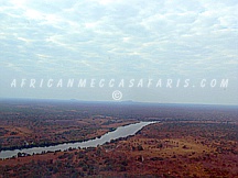
KAFUE RIVER IN ZAMBIA
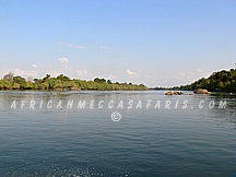
The Kafue River sustains one of the world’s great wildlife environments. It is a major tributary of the Zambezi, and of Zambia’s principal rivers, it is the most central and the most urban, and the longest (about 960 km) and largest lying wholly within the country. The Kafue River rises at an elevation of 1350 meters on the relatively flat plateau just south the border of Zambia and the Democratic Republic of the Congo, 120 kilometers north-west of Chingola in the Copperbelt Province. The river starts as a trickle from the marshy dambos (the Munyanshi Swamp is a tributary) and with little slope to speed up river flow, it meanders south-eastwards sluggishly and within 50 kilometers has the character of a mature river. The area receives about 1200 mm rain in the rainy season, and the river’s channel soon reaches 100 meters wide with a floodplain of fluvial dambos 1-2 km wide. Before the river reaches the Copperbelt towns, however, it loses its wide floodplain, the channel narrows to 30-40 meters and it meanders less, in a shallow valley only 40 meters or so lower than the surrounding plateau. It flows close to the Copperbelt towns of Chililabombwe, Chingola and Mufulira, and through the outskirts of Nchanga and Kitwe. The popular picnic spot the Hippo Pool north of Chingola is protected as a national monument. In the Copperbelt, water is taken from the river to irrigate small farms and market gardens. At Kitwe it changes course to the south-west and flows through forests and areas of flat rock over which it floods in the wet season, keeping to a channel about 50 meters wide in the dry season. It then again develops intricate meanders and a maze of channels in a swampy floodplain, with oxbow lakes and lagoons. It flows 20 kilometers west of the permanent part of the Lukanga Swamp which fills a circular depression, and which drains through a channel into the Kafue.
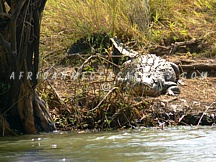
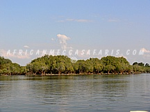
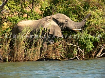
The area between the swamp and river is flood plain and when that and surrounding areas are inundated in the rainy season, the combined wetland exceeds 6000 km². This is the first of the three main wildlife areas of the river, and the least surveyed and protected. The character of the river changes again, as it forms a less meandering dry-season channel with sandy banks and islands. Continuing south-west it enters the Kafue National Park, second largest national park in Africa, where it receives its two largest tributaries, the Lunga and Lufupa rivers, also from the north. The Kafue skirts the south-east edge of the Busanga Plain, one of Africa’s premier wildlife areas, known for large herds of cape buffalo, zebra and antelope. In the rainy season the Lufupa floods the plain. Like the upper Zambezi, Okavango and Cuando rivers, the Kafue used to flow south all the way to Lake Makgadikgadi and the Limpopo River, but the land in that area was uplifted. A rift valley formed running due east of where the Kafue National Park is now, and the Kafue river, eroding a channel called the Itezhi-Tezhi Gap through a ridge of 100 meters high hills, became diverted eastwards. The Itezhi-Tezhi Dam was built in 1977 at the gap and now forms a reservoir 50 kilometers long and up to 10 kilometers wide. In its journey east, the river flows sluggishly across a flat plain called the Kafue Fla ts and for the third time develops intricate meanders in a maze of swampy channels and lagoons. This time however it also has an immense shallow flood plain which no roads or railways cross, 240 kilometers long and about 50 kilometers wide, flooded to a depth of less than a metre in the rainy season (deeper in some lagoons and permanently swampy areas), and drying out to a clayey black soil in the dry season. The Kafue Flats are the third major wildlife area of the river. Tens of thousands of Kafue Lechwe live on the Kafue Flats and are adapted to wading the flood. The area also has one of the greatest variety and concentrations of birds in the world. The Lochinvar and Blue Lagoon National Parks have been established on the flats. Around Mazabuka and as the river gets closer to the town of Kafue, sugar plantations and other large agricultural estates have been established on the fertile black soil and use water from the river in the dry season. The Kafue Flats end at Kafue town and from there, as the rift valley gets deeper, the river drops 550 meters over 60 kilometers through the Kafue Gorge. A second dam, the Kafue Gorge Dam, with a smaller reservoir, generates electricity. The lower Zambezi (originally a separate river) cut back through the rift valleys and eventually captured the Kafue. Their confluence is about 20 kilometers north of Chirundu.