Understand Safari Tier Ratings & Experiences In Zambia | Why Visit Zambia For Your Safari Vacation Or Holidays In Africa
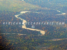
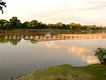
LUANGWA RIVER IN ZAMBIA
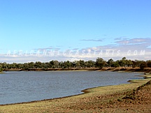
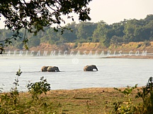
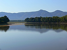
The Luangwa River rises in the Lilonda and Mafinga Hills in north-east Zambia at an elevation of around 1500 meters, near the border with Tanzania and Malawi, and flows in a southwesterly direction through a broad valley. About 150 kilometers from its source it has dropped to an elevation of about 690 meters and becomes a meandering river with a flood-plain several kilometres wide. Over the next 300 kilometers the meanders increase, with many oxbow lakes and abandoned meanders. Near Mfuwe, the river’s elevation has dropped to about 520 meter, the flood plain is about 10 kilometers wide and the valley reaches about 100 kilometers wide, with a north-west escarpment (Muchinga Escarpment) about 700 meters high, and a south-western escarpment about 450 meters high. In the dry season some sections, especially in the upper reaches, dry out completely, leaving isolated pools. The upper and middle parts of the valley contain the North Luangwa National Park and South Luangwa National Park of Zambia, which are among some of the finest in Africa. The river itself is home to large populations of hippopotamuses and crocodiles. The world’s largest concentration of hippos lives in the Luangwa Valley. In the dry season they are restricted by the shrinking river and pools, and are easily seen especially in isolated pools. In addition to being a source of water, the oxbow lakes and pools increase the biodiversity of the valley in other ways. The hippopotamus which live in them feed on land vegetation at night. Their dung feeds some fish and fertilises the pools, increasing fish life which in turn feed crocodiles and birds. In the dry season, the grazing land animals and their predators congregate near the river and pools, and are easily seen.
In the rainy season they graze further afield and are more easily hidden in the growth of new vegetation. At about 500 kilometers the valley narrows to about 50 kilometers and becomes divided by a ridge into two parallel valleys, with a tributary, the Lukusashi River in a 25 km-wide valley to the north-west, and the Luangwa in a 15 km wide valley to the southeast. The river meanders less, and the flood plain narrows. At 600 kilometers the river abruptly enters a narrow valley between hills rising some 200 meters from the broader valley floor, becoming almost a gorge. About 700 kilometers from source the Luangwa merges with its tributary the Lukusashi after the latter has merged with the Lunsemfwa River coming from the opposite driection, and turns due south through a steep narrow valley: this is its exit from the Luangwa Rift Valley (see following section). After only 20 kilometers it emerges from the hills into the broad valley of the Zambezi and meanders over sandy flats about 1.5 kilometers wide in a flood plain of 3-5 kilometers wide. It merges with the deeper Zambezi at Luangwa town. The principal settlement in the Middle and Upper Luangwa Valley is Mfuwe which serves the tourism industry and has an international airport. Very few humans otherwise inhabit the valley.